


'It's a coastline ravaged by nature and steeped in history, there's a story round every single corner ...you're not just looking at a view, you're standing in the footsteps of kings, and all on one of the most dramatic coastlines nature has to offer.'
- Janet Street Porter, Britain's Favourite View, ITV1
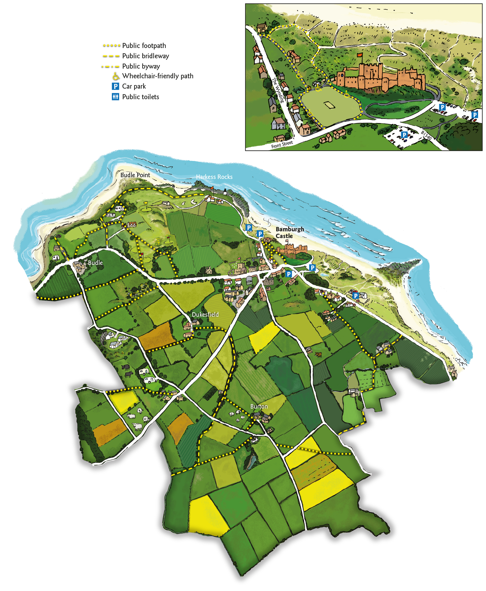
Bamburgh is an ideal base from which to explore the Northumberland coast on foot, with a good network of footpaths, bridleways and of course the beach.
For those wishing to walk that bit further, the Northumberland Coast Path (northumberlandcoastpath.org) passes through the village. This 62 mile (100km) route follows the Northumberland Coast from Cresswell to Berwick-upon-Tweed. Of course you don’t have to walk the whole route; there are some good day-walks from Bamburgh if you use the bus to get back:
- Bamburgh to Belford via Budle Point and Spindlestone Mill - 7 miles. You can continue this walk to Fenwick via St. Cuthbert’s Cave which is another 7 miles. Catch the bus back from the A1 at Fenwick
- Bamburgh to Newton-by –the Sea via Seahouses and Beadnell – 10 miles. A classic! Follow the Northumberland Coast Path south to Seahouses through farmland, or if the tide is out, walk along the beach. Continue south to Beadnell and onto Beadnell bay – in the summer there is a colony of terns nesting on the beach, call in to see the National Trust rangers who will show you the birds. Finish the walk at the Ship Inn with a pint from their own on-site micro-brewery. Catch the 418 bus back from High Newton.
- Craster via Dunstaburgh Castle is another 3.7 miles south of Newton.
Top Tip – for a short walk, head out to Budle Point through the golf course, for one of the finest views in Northumberland.
Use Ordnance Survey Explorer 340 map to plan your own route using the network of quiet roads, bridleways and footpaths that radiate from the village. You can buy a guidebook for the Northumberland Coast Path online (http://www.northumberlandcoastaonb.org/publications/)or from local tourist information offices.
Walking in Bamburgh
Bamburgh is well served by a network of public rights of way. There are 10.55 km of public footpath, 3.35 km of public bridleway and 1.06 km of unclassified road.
The two main bridleways are from the end of the Wynding to Budle and from the B1341 near Dukesfield to Humbleton Hill. A short bridleway links Kiln Point with the road. There is a rich network of footpaths - both in the village and surrounding countryside.
None of these just happened - each one represents an indelible footprint made by previous generations as they went about their everyday lives. Many of them continue to be enjoyed by both residents and visitors, and we have a duty to preserve them as part of our local heritage.
Local Walks
BAMBURGH TO SEAHOUSES - You can walk along the coast from Bamburgh to Seahouses it is approximately 3 miles so you may want to catch a bus back or make a day of it!
SHORT CIRCULAR WALK - The quickest way to the beach is at the far side of the cricket field down past the corner of the castle you can walk along the coast and back or when the tide is out you can walk north along the beach until you come to a painted animal on the rocks (stags rock) from here you can walk up the dunes and back along the golf course road (The Wynding) which is usually quiet and offers beautiful views on a sunny day.